17 September 2015 (22:28 UTC-07 Tango 01, 16 September 2015)/26 Shahrivar 1394/03 Dhu l-Hijja 1436/05 Yi-You (8th month) 4713
Several coastal towns reportedly underwater! Electricity cut off to many places. A 6.4 and a 6.6 aftershocks reported.
17 September 2015 (22:28 UTC-07 Tango 01, 16 September 2015)/26 Shahrivar 1394/03 Dhu l-Hijja 1436/05 Yi-You (8th month) 4713
Several coastal towns reportedly underwater! Electricity cut off to many places. A 6.4 and a 6.6 aftershocks reported.
17 September 2015 (21:43 UTC-07 Tango 01, 16 September 2015)/26 Shahrivar 1394/03 Dhu l-Hijja 1436/05 Yi-You (8th month) 4713
Five deaths now confirmed. Numerous reports of missing people. Choapa Province has been declared a zone of catastrophe! Travel ban in effect in northern Chile! At least one million people being evacuated!
17 September 2015 (21:15 UTC-07 Tango 01, 16 September 2015)/26 Shahrivar 1394/03 Dhu l-Hijja 1436/05 Yi-You (8th month) 4713
One person died from heart attack during quake. Islands near coastline being evacuated. Authorities say the evacuations are just a precaution. 27 aftershocks.
New Zealand’s Ministry of Civil Defence & Emergency Management issued an official tsunami warning. New Zealand is 9131 km (5683 miles) from Chile.
Video shows water in ports rushing out to sea before tsunami came in. Video showing quake damage to major highway Route 5 North.
17 September 2015 (20:37 UTC-07 Tango 01, 16 September 2015)/26 Shahrivar 1394/03 Dhu l-Hijja 1436/05 Yi-You (8th month) 4713
Four deaths reported, three confirmed. The port Sector of Pamilla being evacuated. 23 aftershocks.
President Michelle Bachelet conducting press conference. She will tour damaged areas tomorrow. State of emergency declared.
Military & police now enforcing evacuations and conducting rescue ops. Evacuations continue despite tsunami warnings expiring.
Quake felt in Argentina.
Route 5 North (highway) shutdown by earthquake.
17 September 2015 (20:17 UTC-07 Tango 01, 16 September 2015)/26 Shahrivar 1394/03 Dhu l-Hijja 1436/05 Yi-You (8th month) 4713
After an 8.4 quake hit near the coast of South American country of Chile it’s been almost non-stop aftershocks (at least 16). Reports of 4 meter (16 feet) high tsunami hitting the coastline, the U.S. states of Hawaii and California on tsunami alert.
Hawaii is about 11023 Kilometers (5948 Nautical Miles, 6849.4 Miles) from Chile!
I’ve been watching live news reports and live remote cams and the studio cams seem to be constantly shaking due to the numerous aftershocks. Studio anchors just keep on with their presentation without panic.
The affected area is about the center of Chile’s coastline and areas to the north. School days in affected areas have been canceled, video shows streets in some coastal cities flooding. In other areas where the tsunami hit the streets are littered with debris including large propane tanks.
The USGS continues to say the main quake was 8.3, but Chilian authorities say it was 8.4, and if you understand how the quake scale works that 0.1 difference can be a big deal.
Video of a public swimming pool shows the water being thrown out of the pool by the quake. Route 5 North (highway) shutdown.
The Sumerians were right: The Niburu Planet X System and Its Potential Impacts on Our Solar System “….in 1940 Chilean astronomer Carlos Munoz Ferrada predicted accurately that the powers-that-be would attempt to cover-up Planet X when it comes barreling towards the earth.
Apparently the US government had made the decision to keep Nibiru and its projected earthly destruction under wraps.
It’s believed that the impact of such giant objects crashing into the earth will push the reset button for another axis tilt, likely causing yet another mass extinction and radically altering global climate zones, raising sea levels dramatically to reshape coastlines worldwide, decreasing land mass and increasing oceanic water surface.”
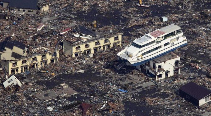
Tohoku University Professor, Toru Matsuzawa, says the biggest earthquake we should expect is magnitude 10. This is based on the Earth’s size and known faults (which have been increasing).
Last year japan suffered a magnitude 9 quake. In 1960 Chile got hit by a magnitude 9.5 quake. A magnitude 10 earthquake will be 32 times more powerful than a magnitude 9!
He says he is only warning people so they can prepare for the worst case scenario, after all, the people of Japan had always been told by officials that the strongest quake they could expect was magnitude 8, with three meter high tsunamis, and look what happened on 11 March 2011.
Recently I saw a emergency preparedness public service announcement (PSA) on TV, it was specifically warning about a major earthquake, using the 1989 Loma Prieta (San Francisco bay area) earthquake as an example.
The latest Federal Emergency Management Agency (FEMA) PSA is part of a new series called The Day Before. Past PSAs were more general in their warnings, why would FEMA now issue a PSA so specific?
Several reports have come out this year, from federal Department of Homeland Security agencies, as well as state agencies, which discuss major earthquakes and tsunamis, including the 1989 Loma Prieta quake. They also reveal a concern about how such things are predicted. As a result many state and local governments (from Virginia to California) have been asked to better prepare for another similar quake.
A July 2012 report by the Pacific Earthquake Engineering Research Center, called Spectral Damping Scaling Factors for Shallow Crustal Earthquakes in Active Tectonic Regions, basically says that current ground motion measurement formulas used to predict earthquakes are not accurate, specifically when it comes to shallow quakes (California has a lot of those, on a weekly basis). Of course they’ve recommended a new formula.
In June 2012, a TsuInfo Alert (Tsunami Information Alert) was presented by Washington State Department of Natural Resources. It concerns the Cascadia Subduction Zone, which affects the North American west coast from northern California up to British Columbia.
The report quotes one scientist who has concerns about how PSAs should be used to prepare the public: “There is no one flyer, no one commercial that’s
going to reach all of these audiences. They all have to be engaged individually, and they have to be approached with something that shows what’s in it for them.”-John Schelling, Washington State Emergency Management Division
The June TsuInfo Alert was packed with warnings about the underestimated effects that earthquakes have in generating tsunamis, not just on the west coast of North America, but including Hawaii and the Gulf of Mexico. The overriding advice for the public is, as one official from New Zealand was quoted: “….don’t wait around, head for higher ground!”-Fred Mecoy, Emergency Preparedness
Manager, Wellington
Officials from the U.S. state of Oregon suggested three basic rules for surviving after a major earthquake/tsunami: “…one can survive three minutes without oxygen, three hours without shelter, three days without water, and three weeks without food.”
Don’t forget hypothermia (part of the “shelter” rule), especially if your dragged out to sea. Many of the tsunami deaths in the March 2011 disasters in Japan were the result of hypothermia, not drowning!
In February I predicted 2012 would be a busy year for earthquakes, specifically around the Pacific Ring of Fire. I count the number of 6.5 magnitude+ quakes, reported by the U.S. Geological Survey as Significant Earthquakes, and so far for 2012 there’ve been plenty.
I count at least 31 6.5+ quakes from 01 January 2012 to 05 September 2012, all of them around the Pacific Ring of Fire!
I counted 13 Significant Earthquakes between 5 and 6.4 magnitude, all around the Pacific Ring of Fire (including some tectonic plates directly in contact with Pacific Ring plates).
When compared to 2011, 31 6.5+ quakes doesn’t seem out of the norm. I counted about 34 such quakes for 2011 (on the USGS Significant list). But remember, 2011 was the year of the great disasters in Japan. Seven of those are quakes and/or aftershocks of the 11 March 2011 Great East Japan disasters (and I only counted up till 05 September).
For Significant quakes between 5 and 6.4 magnitude, I counted only four.
For 2011 there was a total of 38 Significant Earthquakes, from 01 January to 05 September. For 2012 there have been a total of 44 Significant Earthquakes, six more than 2011 during the same time period.
So, while the number of 6.5+ quakes for 2012 are slightly lower than 2011, the number of quakes between 5 and 6.4 are higher (USGS does state that their lists are to be considered “incomplete”). The Gregorian/Western/Christian calender year of 2012 isn’t over, yet.
“I sent off all the hospital staff because I believed that SDF [Self Defense Force] troops and police would arrive at any minute to rescue us.”-Suzuki Ichiro, Futaba Hospital
On 24 July 2012, Japanese media reported that a government investigation, into the rescue efforts after the 11 March 2011 tsunami, actually caused people to die!
In one example the hospital director had the staff evacuate the damaged Futaba hospital thinking the rescue of the patients would be soon. Their rescue was a full two days later, and four patients had died as a result.
The rescue effort at the Futaba hospital still took five days to complete and another 19 patients died!
The recently released government investigation showed that SDF units were not trained to handle such large natural disaster rescues. But to make things worse, the investigation said lack of communications and logistical coordination problems with rescuers were the main problems.
“Those in charge of a lifesaving mission should have handled their task with a stronger sense of responsibility.”-Government report, released 23 July 2012
Local governments are to blame as well. The Fukushima prefectural government had designated four hospitals to receive people from damaged hospitals, but, local government officials never notified the SDF, and they never even notified their own local disaster response task force!
The U.S. Coast Guard took advantage of a Japanese tsunami ghost ship to get some target practice in.
Pictures show the fishing trawler pock marked with holes after being hit by cannon fire. The USCG declared it a shipping hazard.
This is just the beginning wave of flotsam from March 11, 2011’s major tsunami that hit Japan. An estimated 1.5 million tons of houses, boats, cars, bodies and other debris are slowly making their way to North America.
Some analysts from Kyoto University think 90% will hit the North American coast line by October 2012. More than 40 thousand tons will arrive by February 2013.
Of course it all depends on the ocean currents, winds and storms.
Tokyo Electric Power Company has finally looked inside GE designed reactor 4, using an underwater camera.
All they could see was “wreckage” and strange “floating white objects”.
Those same “floating white objects” have been observed in reactor 4’s spent fuel pool. TEPCo said visibility in the spent fuel pool has decreased in the past month.
Visibility is down to one meter (about 3 & half feet), the month prior it was five meters (16 feet)!