Tag Archives: usgs

Fracking quake swarm hits east Idaho?

Update, 11 SEP 2017:  U.S. Geological Survey reports as of 10 SEP 2017 more than 260 earthquakes rocked Caribou County, Idaho!  The USGS believes the quakes will continue but gave no reason why. A professor at Idaho State University claims the swarm quakes are “a whole series of aftershocks”.    USGS quake data is higher than reported by University of Utah, which operates its own seismograph stations independent of the USGS.

03 SEP 2017 (22:38 UTC-07 Tango 06) 13 Sharivar 1396/12 Dhu l-Hijja 1438/14 Ji Yu 4715

A swarm of earthquakes that hit an area east of the rural east-Idaho city of Soda Springs (at least 58 in less than 24 hours) fits the M-O of what the U.S. Geological Survey calls Induced Earthquakes caused by the oil industry’s hydraulic fracturing (fracking).

The individual quakes ranged in magnitude of 2.5 to 5.3, beginning in the late afternoon on 02 SEP 2017 and continuing until late afternoon the next day.   The same area was hit by quakes in October 2016.

In 2016 the Idaho Department of Lands swore that no fracking was taking place in The Gem State, or at least no applications for fracking had been submitted.   Even local news media blow off the skyrocketing quake swarms as signs the supervolcano Yellowstone is coming back to life.  However, I’ve been tracking these swarms for a few years and noticed they coincide with the resumption of petroleum exploration, including fracking.

2017: IDAHO MILITIA RETURNS FROM MALAYSIA, IS IT ABOUT THE OIL?

2016:  Wild Idaho Tide Rising, Forced Oil Pooling near homes, schools and hospitals is Death

IDAHO WATER STANDARDS NIXED FOR FRACKING?

FRACKING SETS AUSTRALIAN RIVER ON FIRE!

IDAHO, OREGON, WASHINGTON HIT BY CONTAMINATED WATER, COINCIDES WITH OIL INDUSTRY FRACKING!

2014: UNEXPLAINED & INCREASING IDAHO EARTHQUAKES CAUSED BY FRACKING?  “In 2012, your asshole ‘elected’ state officials not only legalized fracking but banned your local governments from banning fracking! The new law was co-written by a lobby group called the Idaho Petroleum Council.” 

Idaho Law Review PDF: TRADE SECRETS AND THE MANDATORY DISCLOSURE OF FRACTURING WATER COMPOSITION

Idaho Statesman: Idaho has become an oil-producing state

DATA.GOV: Idaho Oil and Gas Exploration Wells

PBSNewshour: Earthquakes triggered by fracking, not just wastewater disposal

Canadian Broadcasting Corporation: Fracking causes earthquakes

NewScientist: How fracking caused earthquakes in the UK

2011: Temporary Idaho rules for hydraulic fracturing gas wells

Pakistani earthquake causes islands and fire to rise from the Sea! The origin of fire worshiping? Moses high on gas, not God?

25 September 2013 (14:43 UTC-07 Tango)/20 Dhu ‘l-Qa’da 1434/03 Mehr 1391/21 Xin-You (8th month) 4711

In Baluchistan Province, there juts out into the Arabian Sea a free trade port called Gwadar.  About 600 meters (1968 feet) away a new island emerged, within 30 minutes of yesterday’s 7.8 magnitude quake.

Along with the island fire is bursting forth, explorers found lots of dead fish.

The island is 60 meters (196.8 feet) long and 20 meters (65.6 feet) above water level at its highest point.  Explorers said there are lots of dead fish floating around the island, and they smelled methane bubbling up from the sea.  They set it on fire to be sure it was gas, and it was.

Locals say this has happened before, right after a big earthquake in 1960.  The island in that quake was further to the east.  Officials with Pakistan’s National Institute of Oceanography say yesterday’s island creation is the fourth since 1945.   However, these islands are temporary and end up eroding back into the sea, because they’re basically balls of mud.

Pakistan is part of the Indian subcontinent, which is smashing up against the Asian continent.  The ongoing slow impact of the continents create the Himalayas.

Pakistani scientists revealed that the impact of the two continents is also releasing untold amounts of natural gas, from massive deposits underground.

This could explain the origins of the fire worshiping religions, such as Zoroastrianism and some Hindi religions.  Still today, Hindus make a pilgrimage to a mud volcano called Chandragup.  It’s fueled by natural gas.  A nearby cave is also a holy site, where the immortal flame burns.

I recently saw a travel show, which revealed that the eternal flame at a Zoroastrian fire temple, in Pakistan, was built over a natural gas vent.

Archaeologists think the religion of fire worship, begun by Indo-Iranians several thousands of years ago, is also the source for the idea of cremating the dead.

Zoroastrians don’t actually worship fire as ‘god’, but see it as a symbol of god’s purity.  Hindi beliefs say fire is the mediator between people and gods.  Let’s not forget the Hebrews, who’s leader Moses conversed with god, but only through a burning bush.

This brings me to question Moses.  He was probably high on the natural gas escaping from a vent on the mountain, then something caused the gas to ignite (maybe Moses trying to start a camp fire?).

This brings me to the Oracles (fortune tellers) of ancient Greece.  The most accurate oracles lived in caves.  Researchers now believe these caves were natural gas vents, and that the women were high on gas (hence they were ‘full of hot air’).

The oracle at Delphi must’ve known something was going on in the cave, because she limited her fortune telling to once every seven days.  Was the vent gassing off only once per week?

Isn’t the origin of religion funny?  (like laughing gas, hippy-crack aka nitrous oxide)  Too bad those ancient people didn’t think of bottling up that natural gas and selling it for home and commercial use, instead of thinking it was god talking to them!  Still, it doesn’t ‘splain why some of those Greek Oracles were so accurate in their predictions, unless certain types of natural gas are the secret ingredient used to connect your mind to the space time continuum, thus  revealing the future?

Earthquake update: Chinese casualties skyrocketing, more 6+ quakes!

21 April 2013 (16:14 UTC-07 Tango)/10 Jumada t-Tania 1434/01 Ordibehest 1391/12 Bing-Chen (3rd month) 4711

36 hours after a USGS magnitude 6.6 earthquake, and several 5+ quakes, China’s Sichuan Province has been hit with two more magnitude 5+ quakes.  Rescue efforts have revealed more than 186 people killed,  3000 injured and 40000 homeless!

Chinese media reporting more than 1700 aftershocks!

Yesterday I reported seven magnitude 6+ earthquakes for April 2013.  Today a 6.1 quake hit the Izu Islands, near Japan. That makes eight big quakes for the month so far.  During April 2012 there were ten big quakes, we still have a little more than a week and a half left for this April.

Also today, islands along the Aleutian Chain off Alaska got hit with a 5.7 quake.

Magnitude 5+ earthquakes increasing? Several 7+ quakes so far for April 2013!

20 April 2013 (02:02 UTC-07 Tango)/09 Jumada t-Tania 1434/31 Farvardin 1391/11 Bing-Chen (3rd month) 4711

There has been several magnitude 7 earthquakes around the world in just the past three weeks.

The USGS uses a modified type of richter scale magnitude system.  They tried to clear up confusion a few years ago with a press release, but I think it just made things more confusing.

Most western media are using USGS magnitude readings when they report earthquakes, but, several countries have created their own magnitudes that do not match USGS magnitude reports.  I am presenting USGS magnitudes.

The following are the 6 to 7+ magnitude quakes for April, so far:

On 20 April 2013 Sichuan, China, was hit by a 6.6 quake, followed by four 5 quakes.  Reports say at least 152 killed, more than 3000 injured!  The Chinese are calling the initial quake a 7+ magnitude.

Russian Kuril Islands (on the Pacific Ring of Fire) were hit with a 6.1 magnitude quake, followed by a 5.3 quake.

On 19 April 2013, again the Russian Kuril Islands, hit with a 7.2, then a 5.7.  The Kuril Islands have been experiencing many magnitude 5 and 6+ quakes since the beginning of this Gregorian year.

For more example of how different quake reports are used by different countries, on 18 April 2013, Japanese officials reported a 7 magnitude quake off the coast of northern Japan. However, the USGS did not report such a quake.  It is possible that the Kuril Islands 7.2 quake reported on early 19 April by USGS is the same quake that Japan claimed on the 18th.  Japan and Russia both have claims to some of the Kuril Islands.

On 16 April 2013, a 7.8 quake hit along the Iran-Pakistan border.  At least 40 people killed, mainly on the Pakistani side.

Papua New Guinea (on the Pacific Ring of Fire) 6.6 quake.

On 14 April 2013, again Papua New Guinea hit with 6.6 quake.  The island country has also been experiencing many magnitude 5+ quakes.

06 April 2013, Indonesia (Pacific Ring of Fire) a 7 quake.

From 01 April to 20 April 2013 there have been at least seven magnitude 6+ quakes.  For all of April 2012 there were ten magnitude 6+ quakes (which included two 8+ quakes near Sumatra on the Pacific Ring of Fire).  We have a little under a week and a half left for April 2013, will mother Earth break last years April numbers?

By the way, officials in San Francisco, California, just passed new earthquake safety rules.  The new law forces owners of wooden framed multi-story buildings to reinforce the lower walls and to help distribute the weight of the building more evenly on the frame.  It’s estimated it will cost property owners $60000 to $130000 USD per building.  The law comes after years of study by seismologists.

Pacific Ring of Fire getting hammered? Why is FEMA running emergency preparedness PSA specifically about the 1989 Loma Prieta quake?

Recently I saw a emergency preparedness public service announcement (PSA) on TV, it was specifically warning about a major earthquake, using the 1989 Loma Prieta (San Francisco bay area) earthquake as an example.

The latest Federal Emergency Management Agency (FEMA) PSA is part of a new series called The Day Before.  Past PSAs were more general in their warnings, why would FEMA now issue a PSA so specific?

Several reports have come out this year, from federal Department of Homeland Security agencies, as well as state agencies, which discuss major earthquakes and tsunamis, including the 1989 Loma Prieta quake.  They also reveal a concern about how such things are predicted. As a result many state and local governments (from Virginia to California) have been asked to better prepare for another similar quake.

A July 2012 report by the Pacific Earthquake Engineering Research Center, called Spectral Damping Scaling Factors for Shallow Crustal Earthquakes in Active Tectonic Regions, basically says that current ground motion measurement formulas used to predict earthquakes are not accurate, specifically when it comes to shallow quakes (California has a lot of those, on a weekly basis).  Of course they’ve recommended a new formula.

In June 2012, a TsuInfo Alert (Tsunami Information Alert) was presented by Washington State Department of Natural Resources.  It concerns the Cascadia Subduction Zone, which affects the North American west coast from northern California up to British Columbia.

The report quotes one scientist who has concerns about how PSAs should be used to prepare the public: “There is no one flyer, no one commercial that’s
going to reach all of these audiences. They all have to be engaged individually, and they have to be approached with something that shows what’s in it for them.”-John Schelling, Washington State Emergency Management Division

The June TsuInfo Alert was packed with warnings about the underestimated effects that earthquakes have in generating tsunamis, not just on the west coast of North America, but including Hawaii and the Gulf of Mexico.  The overriding advice for the public is, as one official from New Zealand was quoted: “….don’t wait around, head for higher ground!”-Fred Mecoy, Emergency Preparedness
Manager, Wellington

Officials from the U.S. state of Oregon suggested three basic rules for surviving after a major earthquake/tsunami: “…one can survive three minutes without oxygen, three hours without shelter, three days without water, and three weeks without food.” 

Don’t forget hypothermia (part of the “shelter” rule), especially if your dragged out to sea.  Many of the tsunami deaths in the March 2011 disasters in Japan were the result of hypothermia, not drowning!

In February I predicted 2012 would be a busy year for earthquakes, specifically around the Pacific Ring of Fire.   I count the number of 6.5 magnitude+ quakes, reported by the U.S. Geological Survey as Significant Earthquakes, and so far for 2012 there’ve been plenty.

I count at least 31 6.5+ quakes from 01 January 2012 to 05 September 2012, all  of them around the Pacific Ring of Fire!

I counted 13 Significant Earthquakes between 5 and 6.4 magnitude, all around the Pacific Ring of Fire (including some tectonic plates directly in contact with Pacific Ring plates).

When compared to 2011, 31 6.5+ quakes doesn’t seem out of the norm. I counted about 34 such quakes for 2011 (on the USGS Significant list). But remember, 2011 was the year of the great disasters in Japan. Seven of those are quakes and/or aftershocks of the 11 March 2011 Great East Japan disasters (and I only counted up till 05 September).

For Significant quakes between 5 and 6.4 magnitude, I counted only four.

For 2011 there was a total of 38 Significant Earthquakes, from 01 January to 05 September.  For 2012 there have been a total of 44 Significant Earthquakes, six more than 2011 during the same time period.

So, while the number of 6.5+ quakes for 2012 are slightly lower than 2011, the number of quakes between 5 and 6.4 are higher (USGS does state that their lists are to be considered “incomplete”).  The Gregorian/Western/Christian calender year of 2012 isn’t over, yet.

Pacific Ring of Fire: April 12, Two quakes hit Gulf of California, four more in Sumatra

For April 12, 2012, around and adjacent to the Pacific Ring of Fire (PRoF) there have been 10 magnitude 5+ quakes.

Gulf of California: 6.2 and 6.9  (USGS saying the epicenters were in the Gulf of California, but news media reporting it being felt in Mexico City)

West Coast northern Sumatra: two 5.0s, 5.1 and 5.3

East coast Honshu, Japan:  5.3 and 5.6

North Indian Ocean (adjacent to/borders PRoF): two 5.0s

Red Horse, Leviathan & World War 3: It’s about the Oil & Gas, huge reserves found off the coast of Cyprus, Gaza, Greece, Egypt, Israel, Libya, Lebanon, Turkey & Syria. The real reason for War with Iran!

“…its gas resources are bigger than anything we have assessed in the United States!”-Brenda Pierce, U.S. Geological Survey, statement about the Levant Basin Province (aka Leviathan)

The discovery of huge natural gas reserves in the Mediterranean Sea is the true cause of warmongering between the United States, Europe, Cyprus (which is divided into Greek and Turkish halves), Turkey, Syria, Lebanon, Israel, Iran and Palestinian Gaza Strip.

In 2009, Texas U.S.A. based Noble Energy (formerly known as Noble Affiliates, and not to be confused with Nobel Energy Management) discovered a huge gas field while under hire by Israel.  It was the biggest gas field discovery of 2009, called Tamar.

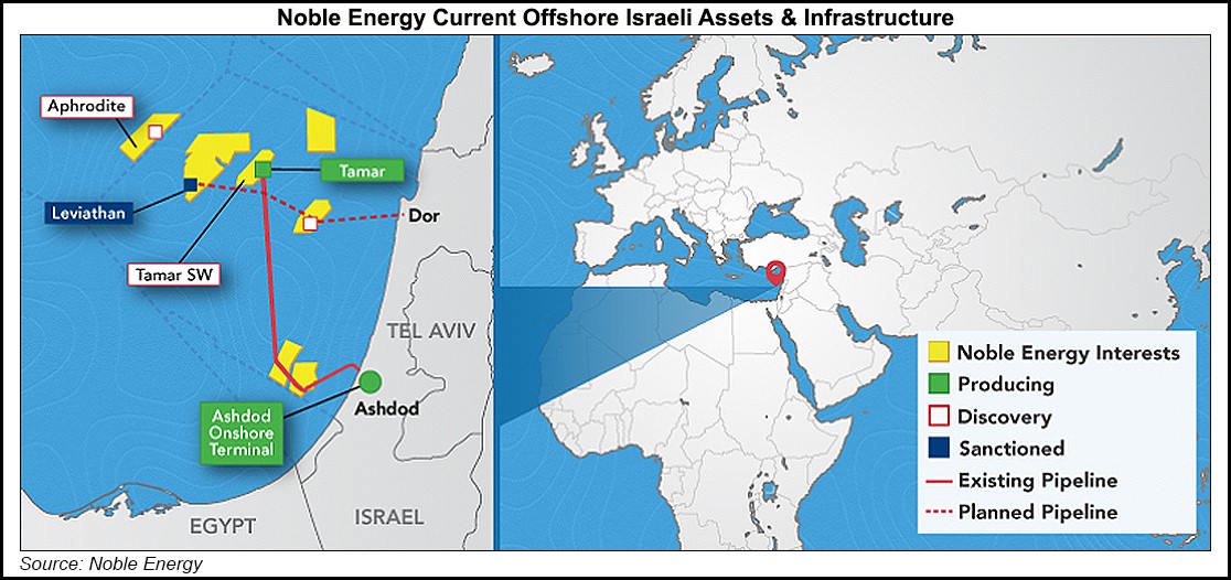
Image via Noble Energy.

In October 2010, Noble Energy discovered an even bigger gas field. Israel declared the area an Exclusive Economic Zone.  It’s part of an even bigger area known as the Leviathan Gas Field. The problem is that Lebanon says the field extends into its territory and on August 2010, almost two months before the second discovery by Noble Energy, petitioned the United Nations to protect their rights.

Lebanon’s Parliament Speaker, Nabih Berri, said Israel is “…ignoring the fact that according to the maps the deposit extends into Lebanese waters.”

Lebanon is justified, as Israel (along with the United States) never ratified the 1982 UN Convention on Law of the Sea.  Under that law Lebanon has a right to the gas, in the field called Tamar.

Israeli officials responded with threats of war: “We will not hesitate to use our force and strength to protect not only the rule of law but the international maritime law.”-Uzi Landau, Minister of National Infrastructure of Israel

Note how Israeli officials always make claims of enforcing international laws, yet they have refused to sign onto most of those laws!

In fact Israel periodically sends military aircraft into Lebanon’s air space, and even drops a few bombs now and again.

But, the Leviathan Gas Field doesn’t involve just Israel and Lebanon. In December 2011, NATO-Turkish warships began firing on an area of the Mediterranean where Cyprus had just discovered an extension of the Leviathan Gas Field.  Cyprus declared the area an Exclusive Economic Zone, it is also known as Block-12 of the Leviathan Gas Field.

Greek Cypriot officials issued not only words of war, but threats of Ethnic Cleansing: “If Turkey does not change its gunboat diplomacy and stop playing the part of regional police officer, there will be consequences which, for sure, will not be good, either for the whole region or the Turkish people and first and foremost for Turkish Cypriots.”-Dimitris Christofias, Greek President of Cyprus

For some reason the Western media has not reported much of anything about the disputes over the Leviathan Gas Field.

2011 was also the year that NATO-Turkey went from being Israel’s only ally in the region, to becoming an enemy.  Turkey officially blamed it on Israel’s blockade of humanitarian aid ships to Gaza, but it looks like it’s really about the gas.  By the end of 2011, Israel canceled a $90-million military contract with Turkey, because Israeli officials felt Turkey was after their portion of the gas field.

Israel has allied itself with Greek Cyprus, when it comes to extracting the natural gas.  While Noble Energy is officially a Houston, Texas, company, most of the company stocks are actually held by petroleum companies of Greek Cyprus (Cypriot national energy company) and Israel (Delek Drilling LP & Avner Oil Exploration LLP).

Noble Energy claims there is 33-trillion cubic feet of natural gas in the Leviathan fields, enough to provide Israel with 100 years worth!  In fact, the United States government is so interested that the U.S. Geological Survey (USGS) was sent in to confirm its size.

You might remember that, in 2011, for a short time it looked like Israeli-U.S. relations were deteriorating. Again, the Western media failed to report that U.S. officials told Lebanese officials that the U.S. supported their claim to the Tamar gas  fields!

The U.S. mended their relations with Israel, by taking a stand against Turkey’s desire to control a portion of Leviathan.  U.S. officials did this by supporting Israel’s new ally Greek Cyprus.

U.S. Secretary of State, Hillary Clinton, told the Greek Cyprus Foreign Minister, Erato Kozakou-Marcoullis, to go full bore on drilling their gas field.     Kozakou-Marcoullis told a crowd at the Woodrow Wilson International Center for Scholars that Turkey was “the neighborhood bully”, and that the United States was fully supporting Greek Cyprus (thus, in a round-a-bout way Israel) in their gas field operations.

February 16, 2012, Israeli Prime Minister Benjamin Netanyahu made a historic first time visit to Greek Cyprus.  He called the new alliance a “natural relationship”, and added:  “I came here to develop our bilateral ties, our economic ties and ties in the field of energy.”

Oh, but wait, Turkey now looks to be Israel’s ally again. In fact Turkey has switched from supporting Syria to supporting military action against Syria!   What happened?

Turkey has realized that by connecting a relatively short pipeline to Leviathan, they could potentially become self sufficient in natural gas, and maybe even oil.  This would end their current dependence on petroleum from the Black Sea (Russia, Romania), and make it no longer a necessity to connect to the planned pipeline coming from Iran.

What about NATO-Greece? Ever notice how this economic disaster just keeps dragging on? It could be because Greece is a transit rout for oil and gas pipelines coming from the Caspian Sea, and Middle East (namely Iran).  These so called bail out negotiations are more likely efforts to get Greece to join Leviathan.

The problem for Greece is that it would need a very long expensive pipeline to connect to the known gas/oil reserves of Leviathan, meaning it’s still cheaper to get their petroleum from the Middle East!  It’s also still cheaper to continue getting their petroleum from the Middle East, than to buy it from those countries (Israel, Cyprus, etc) that are planning to mine Leviathan for everything it’s got.

This is the real reason Greece is being run into the ground.

By the way, want to know what the USGS found when they explored the Eastern Mediterranean?  Potentially, 345-trillion cubic feet of natural gas, and 3.4-billion barrels of oil!!!

This sheds new light on the real reasons for the 2011 overthrow of the Egyptian and Libyan governments in North Africa!  The people of those countries were justified, but look what it’s got them; increasing instability in Libya, and a pro-U.S.-Israel military government in Egypt.

And what about the almost daily Israeli military attacks on the Gaza Strip, for the past two years, that the Western-NATO news-media is not reporting!?  The latest attack, on February 26, saw Israeli planes bomb a cement factory.  The week prior saw Israeli forces cut off electrical power to Gaza.  On and on.  Yet barely any mention in Western mainstream news-media.

What countries surround the Eastern MediterraneanCyprus, Gaza, Greece, Egypt, Israel, Libya, Lebanon, Turkey and Syria!!!

And what about this urgent need to go to war with Iran? It’s not about anything nuclear!  Lebanon & Syria (Eastern Mediterranean countries) and Iraq & Iran are a few years away from completing the largest natural gas pipeline in the Middle East.  It would rival anything that could be immediately extracted from Leviathan.

“A trilateral agreement between the three countries on the transit of gas has been reached….The first official contract is ready to be signed soon…We plan to transit gas from the South Pars field through Iraq, Syria and then Lebanon to the Mediterranean area and Europe.”-Javad Oji, National Iranian Gas Company

The pipeline from Iran could carry 110-million cubic meters of natural gas per day, for the next 80 years (Iran has the world’s second largest reserves of natural gas)!  If this was completed, then it would make developing the Leviathan (new drilling rigs, pipelines, etc) a waste of money.  And, the money made off the Iranian dominated pipeline would not be going to the West (ie no benefit to the U.S./U.K./Saudi Arabian U.S. PetroDollar monopoly)!

It would also destroy Israel’s hopes of finally joining the petroleum club.

The other factor, that has most of the European Union in favor of Leviathan (except Greece, by the way some NATO-German officials are now saying Greece needs to get out of the EU), is the fact that current eastern European pipeline projects are turning out to be more expensive than first thought.  So much so that some reports (including reports by British Petroleum [BP]) say it would be cheaper to dump those projects in favor of developing Leviathan.  But of course, that’s only if Leviathan didn’t have to compete with the huge pipeline coming from Iran.

In fact, as of February 26, Leviathan now has to compete with several gas lines coming from Iran. Iranian gas officials announced they are now building secondary pipelines to Iraq, Syria and on to Europe!

Because the Western media does not report what’s really going on regarding the recently discovered Eastern Mediterranean oil and gas fields, and only reports propagandist lies meant to rally people in support of unjust wars for the benefit of the oil industry,  it shows that the Western news media is a tool of deceit for the Red Horseman.

“Then another horse came out, a fiery red one. Its rider was given power to take peace from the earth and to make men slay each other.”-Revelation 6:4

Pacific Ring of Fire Seismic Events: 2012 already shaping up to be big?

In past postings I reported on what appears to be the average number of magnitude 6.5 or greater earthquakes that hit the Pacific Ring of Fire.

In going through the USGS’s Significant Earthquakes of the World, all the way back to 1999, it seems the Pacific Ring of Fire has about 50 per year.

The Pacific Ring of Fire involves not only the Pacific Plate, but the Nazca Plate, the Antarctic Plate, Cocos Plate, Juan de Fuca Plate, North American Plate, South American Plate, Scotia Plate, Filipino Plate, Eurasian Plate and Australian Plate, whew!

Well, from January 1 to February 12, 2012, there have already been seven “significant” earthquakes involving the plates of the Pacific Ring of Fire.  In fact, so far, the only significant quakes for 2012 have been the seven around the Pacific Ring of Fire!

What about earthquakes in general?  If you look at the USGS’s list of quakes from January 13 to February 4, 2012, the overwhelming majority are around the Pacific Ring of Fire.  I counted at least 453 reported earthquakes around the Pacific Ring.

Most of the quakes are hitting Japan (with the most), California, Alaska, Mexico, Chile, countries on the Filipino Plate (like Indonesian islands getting hit almost as much as Japan), New Zealand and Vanuatu.

Vanuatu is a Southwestern Pacific Island north of New Zealand.  Since the beginning of February it’s getting hit almost daily with quakes ranging from magnitude 4 to 5.